|
|
Post by smithleback on Jul 21, 2015 18:30:49 GMT
fished above bridge about 500yds up on sunday,stayed while 9,loads of bits nowt on heavier gear,agree totally,needs some water,ouse next i think[matches permitting]
|
|
|
|
Post by johnboy66 on Jul 21, 2015 21:34:06 GMT
jhop
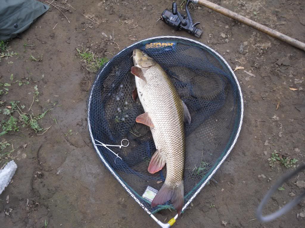
where you there last Wednesday in horse`s field I was there that day, tried a peg above railway bridge for an hour or so with just a couple of bites then slipped in to 2nd peg above layby bridge. had a nice little untouched Chub about a 1lb to lb and 1/2 on double sweet corn, there was a lot of small fish topping in front of me but didn't have my float gear.
JB.
|
|
jhop
Junior Member

Posts: 66 
|
Post by jhop on Jul 22, 2015 14:25:24 GMT
Was there Friday Johnboy, fished below bridge hence river running left to right. Was on big bend near bottom of length then moved 5-6 pegs further up to peg in picture with island.
|
|
|
|
Post by johnboy66 on Jul 22, 2015 19:53:54 GMT
Was there Friday Johnboy, fished below bridge hence river running left to right. Was on big bend near bottom of length then moved 5-6 pegs further up to peg in picture with island. that peg was a banker years ago for Barbel as you say jhop needs water in might have to wait till September / October, these showers are just running off. |
|
|
|
Post by nige_LS7 on Jul 22, 2015 19:55:34 GMT
Where is the bottom of the length? It's one of the few stretches not on the map.
"A mile downstream" is a long way but I find the distances in the club info can be very approximate indeed.
Is Barnes Farm, as mentioned in Graham's description of the limit in another thread (about the working party). the same as Skip Bridge Inn Farm, and therefore is the end of the stretch (and the bend you're describing Jez) more or less due north of that farm?
|
|
|
|
Post by patterdalewilson on Jul 22, 2015 21:16:37 GMT
As I understand it the maps on the website are correct , perhaps not to accurate scale but in brief we have the left bank from the field above the weir down to the old road bridge. Then a short length of the right bank between the bridges.
Not sure where Barnes Farm comes into the equation , Leeds used to have this but I thought we gave it up some years back.
Please correct me if I have got this wrong !
Mick.
|
|
|
|
Post by nige_LS7 on Jul 22, 2015 21:22:30 GMT
As I understand it the maps on the website are correct , perhaps not to accurate scale but in brief we have the left bank from the field above the weir down to the old road bridge. Then a short length of the right bank between the bridges. Not sure where Barnes Farm comes into the equation , Leeds used to have this but I thought we gave it up some years back. Please correct me if I have got this wrong ! Mick. we definitely have the right bank below the new road bridge (I've fished it), but it isn't on the map at all. |
|
|
|
Post by patterdalewilson on Jul 22, 2015 21:38:28 GMT
Thats interesting Nige is the signage in place ? I presume not otherwise you would know where the bottom limit was.
Is the only access from the road bridge I wonder.
|
|
|
|
Post by Eddie on Jul 22, 2015 21:40:00 GMT
Here's the old Leeds map book plan of the Barnes farm length.  Eddie. |
|
|
|
Post by nige_LS7 on Jul 22, 2015 22:48:55 GMT
Thats interesting Nige is the signage in place ? I presume not otherwise you would know where the bottom limit was. Is the only access from the road bridge I wonder. You can access from the layby over locked gates (and a "no access for the public" sign on the gate, but i'm not public, I'm a Leeds Angler  , then under the bridge and over another locked gate, then over a choice of two stiles onto the river bank (stiles which seem at first to keep you separate on the bank from a beef herd, but don't at all, so you have to look out for cattle because they get in through a gap somewhere, looking for a drink and shade, and the spaces are quite confined as the result of the fence along the top of the bank) No Leeds signs at that end - and I just haven't had a chance to rove more than a few hundred yards down. Had just one cast in each of six different spots so far! No bites but I did think it looks very promising. Thanks for posting the map Eddie - that's answered my question - so yes it's the same farm - so there is also access via the public footpath that goes through the farm? Worth knowing. |
|
smiley
Junior Member
Posts: 87
|
Post by smiley on Jul 22, 2015 23:47:37 GMT
Whoa!! Nige. It would appear there is a public foot path through Barnes farm but I'm not sure the farmer would take kindly to anglers accessing the river bank that may not be his property. Best not to take that route and walk down from Skip bridge, sorry.  Keith. |
|
|
|
Post by nige_LS7 on Jul 23, 2015 11:43:57 GMT
Whoa!! Nige. It would appear there is a public foot path through Barnes farm but I'm not sure the farmer would take kindly to anglers accessing the river bank that may not be his property. Best not to take that route and walk down from Skip bridge, sorry. Keith. Not sure where your "whoa" comes from as I haven't said I'm going to do anything and haven't made any assumptions. That's why I'm asking the question - to Jez or anyone who has fished the stretch recently - because like you, I'm not sure either. It does look as if former access was that way (Eddie's map is from an old yearbook), but that may have been a generation ago. It seems the stretch limits were different then, and it does seem that there's a property boundary north of that farm where our stretch now ends, east of which there may well be another owner. I wouldn't assume anything and may well ask the farmer one day - the walk from Monkey Moorton along that path to Skip Bridge (and probably continuing via Wilstrop Grange down to Marston Moor battlefield - I'm a history nut, as well as wanting to glimpse the mythical Horseshoe Bend from the opposite bank ) is one that's been on my 'to do' list anyway. |
|
|
|
Post by Eddie on Jul 23, 2015 12:05:44 GMT
High all, I posted the plan from the old map book (circa 1985) because I thought it would be of interest, but don't take the old access as a right of way. Anyway here's the other map showing the other lengths. As said just out of interest and to have a look at the old hand drawn plans.  Eddie. |
|
|
|
Post by nige_LS7 on Jul 23, 2015 12:10:38 GMT
Cheers Eddie.
And the saddest thing of all is that Kirk Hammerton is now publess.
Looks like there was no parking in the layby back then too. Access to the horsefiled was through the top gate nearer the garage.
Another non-fishing question - the horses round there are particularly beautiful - in the horse fields either side of the track under the railway, but also on the opposite side to our stretch below Skip Bridge - does anyone know if that's connected with the nearby harness race track? Do they breed chestnut harness racers there?
|
|
|
|
Post by Eddie on Jul 23, 2015 13:32:46 GMT
I don't know who went to the trouble of drawing the maps of what were about 50 venues back then, no doubt I will be able to credit them with a name if I do a bit of asking.
But if still with us hope the fact that someone hung on to a set shows they were appreciated and still in the car when I go to new venues even today.
Eddie.
|
|


 , then under the bridge and over another locked gate, then over a choice of two stiles onto the river bank (stiles which seem at first to keep you separate on the bank from a beef herd, but don't at all, so you have to look out for cattle because they get in through a gap somewhere, looking for a drink and shade, and the spaces are quite confined as the result of the fence along the top of the bank)
